Deleted OSM Elements
This is a map in the "default" osm-carto style but exclusively based on deleted OSM elements. Note that these are not ALL deleted elements. Many elements get deleted
As one can see, the OSM community seems to have mapped the globe not only once but twice. Most areas are recognisable by looking at the deleted elements alone. Apart from removing duplicates or entities that in fact disappeared, mappers seem to often find it more convenient to delete and redraw an object, instead of changing the current geometry. "Let's try to keep and improve the original element, to give its creator the due credit in the elements history!" said the HOT team during their workshop at SOTM2022, to name just one advantage of 'conservative' mapping. 'Delete-and-recreate' also has an impact on OSM history analyses, to name another example, because the element history no longer contains the full picture.
A deletion is not always a bad thing. Some of the deletions are corrections, some are mistakes, others are neither. But some of them are examples of vandalism, which we do not approve of! This map will not be updated, so future vadals will not be given a stage here! OSM is not meant for this kind of 'creativity', but other projects like https://opengeofiction.net specifically target creative map makers.
Looking at the content of the map, here are some interesting locations we have found so far. You can use the in-line buttons to auto-focus the map and use the layer switcher (top right) to compare the deleted map to the current situation. Note that some elements (like the river Rhine in Germany or the country boundaries of Israel) are part of the base data used by the tile server for rendereing. These are not part of our set of deleted elements.
- madness including and from the video game GTA V
- on the north-western tip of James-Ross-Island and on the western part of Alexander Island in Antarctica of which we could not find any evidence of existence. Antarctica seems to generally experience a relatively high amount of vandalism. The bar seems to be another example.
- , south-west of Jerusalem is a UNESCO World Heritage site for its cultural landscabe of agricultural terraces. The retaining walls that form these terraces have been cleaned up in the past, making the deleted map a psychodelic experience.
- Globe-crossing highways, e.g. near or Germany.
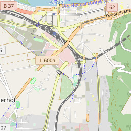
- being redrawn multiple times in Heidelberg, Germany.
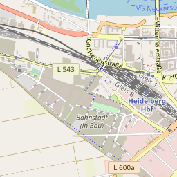
- in Heidelberg (Bahnstadt), Germany. Constructions sites are meant as temporary objects and should be deleted after completion. Therefore these deletions are very welcome.
If we were to use the raw data, the western hemisphere would be very ugly in high zoom levels with a uniform gray background blocking much detail. This is due to some globe-spanning buildings that have been deleted. The issue was solved by placing these buildings into a separate toggleable layer.